NSF-Funded DesignSafe Secures Instruments for Community Resilience Studies
Engineers and social scientsists developed and standardized survey tools for NIST-funded longitudinal study of Lumberton, North Carolina
Published on June 23, 2021

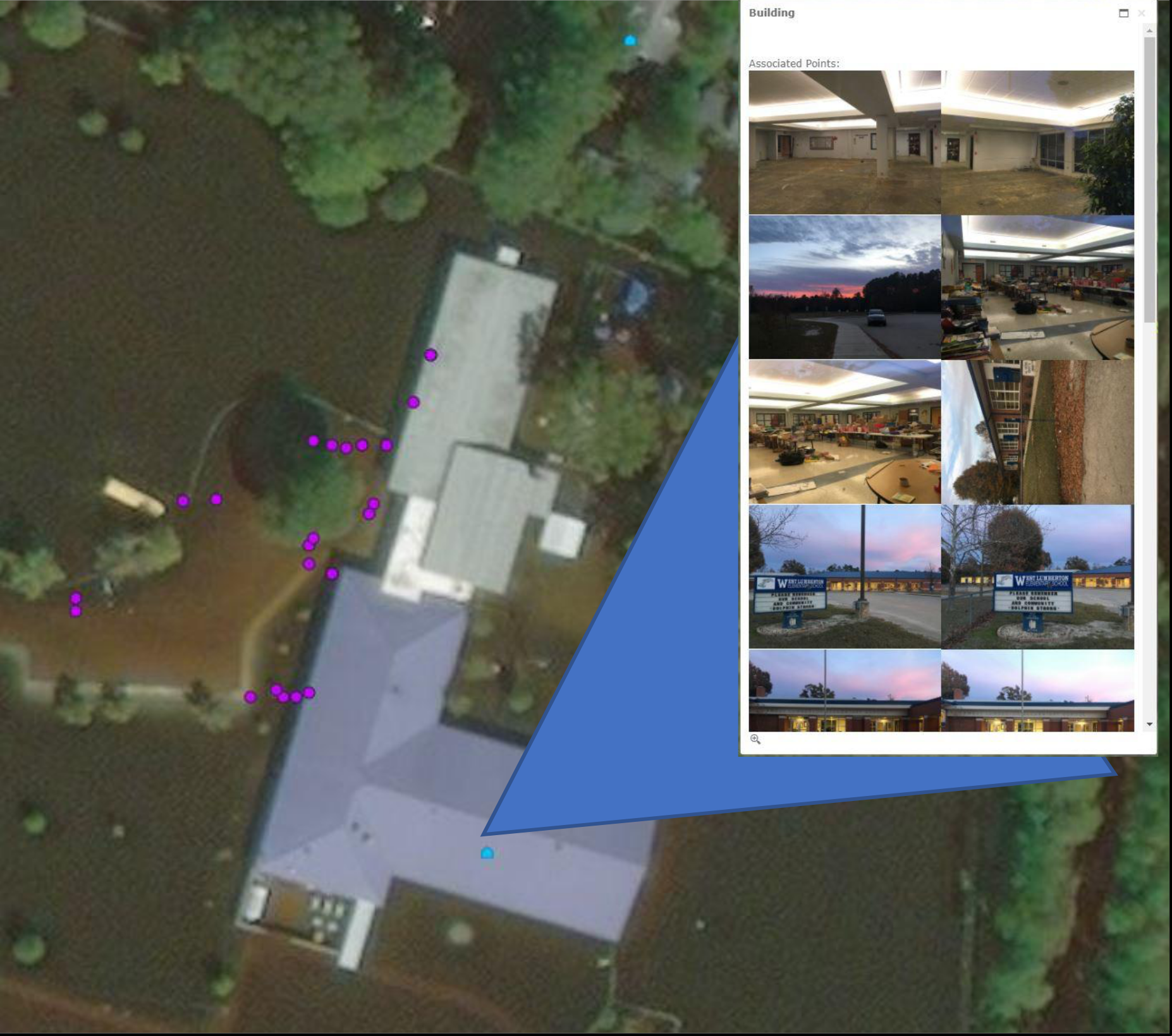
West Lumberton Elementary School with associated photographs.
In October 2016, rains from Hurricane Matthew caused the Lumber River to overflow and flood Lumberton, North Carolina, a small city of about 20,000. A racially and ethnically diverse community with higher-than-average poverty and unemployment rates, Lumberton also experienced a wide spectrum of effects on the built environment including homes, businesses, and schools. Given its size and the range of effects of the disaster across different geographic locations and population groups, it is an ideal community for studying the long-term effects of a disaster.
A joint team from the Center for Risk-Based Community Resilience Planning and the National Institute of Standards and Technology launched an initial rapid response field study that has become a long-term examination of the ways communities recover from disasters. The work is in collaboration with NISTs Disaster and Failure Studies, Community Resilience, and Applied Economic Programs; the longitudinal study continues to be funded as part of the Center, headquartered at Colorado State University. The purpose of the field study is to collect necessary data for validating the Centers Interdependent Networked Community Resilience Modeling Environment, IN-CORE, a virtual platform for resilience analysis.
This longitudinal study will provide researchers throughout the Center and NIST the ability to validate interdisciplinary recovery models for the first time, said John van de Lindt, co-director of the Center. The ultimate goal is to ensure that this scientific information makes it into the hands of decision-makers who can improve community resilience.
INTERDISCIPLINARY DATA MANAGEMENT
Among the novel aspects of this study is its interdisciplinary approach to data management. The Lumberton field-study team, comprised of engineers and social scientists, used the NSF-funded DesignSafe Cyberinfrastructure to design a cross-disciplinary data model and to curate study protocols and survey instruments. DesignSafe is a component of NSFs Natural Hazards Engineering Research Infrastructure (NHERI) network, a public resource for the natural hazards community.
Field study leader Elaina Sutley, assistant professor in civil engineering from the University of Kansas, says the team chose the DesignSafe data repository because, as part of the NHERI network, its tools are tailored for the natural hazards community.
The DesignSafe team was willing to help us develop a unique, integrated, engineering-social science data model, Sutley said. Further, DesignSafe has a large user-base of researchers involved in interdisciplinary hazards and disasters. So, it was a natural fit.
Specifically, the NIST-funded Lumberton study served as an ideal project for designing a cross-disciplinary data architecture for publishing social science, engineering, and interdisciplinary natural hazards data. This novel data model functions as a template to standardize data organization and description and clarifies how different data and documentation components relate to one another.
NOVEL DATA MODEL
The data model, which was developed in partnership with social scientists from NHERI CONVERGE and engineers from the NHERI RAPID facility, is robust enough for researchers to publish qualitative and quantitative data as well as data collection protocols, research instruments, and Institutional Review Board (IRB) protocols. Sutley, along with Nathanael Rosenheim, associate research scientist at Texas A&M University, worked closely with Lori Peek, principal investigator of CONVERGE, NHERIs cross-disciplinary component, and Maria Esteva, data curator with DesignSafe.
The field study team, which involves NIST researchers and academics from 11 institutions across the U.S., has prepared and used a variety of survey instruments to document damage, disruption, impact, and recovery of Lumberton households, housing units, and businesses following Hurricanes Matthew and Florence including during the COVID-19 pandemic.
Four of the data-collection instruments, as well as the five-year IRB protocol with amendments for these data, are now published on the DesignSafe repository, called the Data Depot. The materials are available within a larger project file titled A Longitudinal Community Resilience Focused Technical Investigation of the Lumberton, North Carolina Flood of 2016.
Publishing the field-study tools and IRB protocol on DesignSafes Data Depot gives the NHERI community, and all professionals in natural hazards, access to the cross-disciplinary instruments and the research protocol that informed data collection efforts.
Maria Dillard, acting director of NISTs Disaster and Failure Studies program, emphasizes the vital importance of standardizing post-disaster data collection. We are moving the field toward a future when we will have comparable datasets across disaster events. Standardized datasets broaden our ability to understand disaster impacts and recovery in the long term, as well as determine the fundamental elements of community resilience.

Screenshot of Google My Maps for Lumberton area.

Sampled Housing Units (1 mi = 1.6km)
A CROSS-DISCIPLINARY TEAM
A subset of the Center, the Lumberton field-study team has members with expertise spanning structural engineering, coastal engineering, operations research, sociology, urban planning, and economics.
Since October 2016, the field-study team has completed five in-person data collection trips, and in June 2021, wrapped up a virtual data collection amidst the COVID-19 pandemic. In deployments, cross-disciplinary scholars are paired together. This approach has allowed social scientists to be trained in forensic damage measurement, and engineers to be trained in human-subjects research and survey data collection.

Survey Instruments available in the DesignSafe Data Depot.

Institutional Review Board preapproval paper in Risk Analysis.
IRB PROTOCOL AND INTERDISCIPLINARY SURVEY INSTRUMENTS
In line with the goal of validating the IN-CORE modeling environment, the data collection procedure is exacting. The Lumberton survey instruments were developed through a rigorous process that included input from many multi-disciplinary experts. Each survey instrument, for example, offers unique questions based on the timing it was used after the disaster event and also asks some shared questions to document recovery progress over time. In addition, there are distinct instruments for collecting data from business owners, households, and other residents of the affected community, which could be adopted in other disaster-affected areas.
The collaborative field studies between NIST and the NIST Center of Excellence are viewed as an important opportunity to test and evaluate tools for improving disaster metrology, said NISTs Dillard. We want to better understand the intersection between physical damage and societal impacts.
Before launching the first field study investigation in Lumberton, the team needed IRB authorization to conduct its human-subjects research. Each investigator engineers and social scientists alike completed extensive IRB training, and their various institutions joined together under one collaborative IRB Authorization Agreement.
This allowed our large and dynamic team to work together and to rapidly mobilize in the face of the flooding in Lumberton, said Lori Peek, who helped to lead the IRB authorization effort. Peek, Jennifer Tobin, John van de Lindt, and Anne Andrews recently co-authored an article in Risk Analysis describing how engineers and social scientists came together to conduct human-subjects research in Lumberton. The IRB authorization also allowed the cross-disciplinary team to co-develop its interview guides and survey instruments, which are curated and published on DesignSafe.
PROJECT OUTCOMES TO DATE
The Lumberton field study team has released two reports detailing the post-hurricane effects on the city of Lumberton. The Wave 1 report, released in October 2018, documents the initial physical and socio-economic impacts of the flooding on the community. The Wave 2 report, released in April 2021, details the initial hurricane recovery process. The project team encourages natural hazards researchers to explore its data model, survey instruments, and IRB protocol on DesignSafe.


